PM2.5 Modeling and Historical Reconstruction over the Continental USA Utilizing GOES-16 AOD
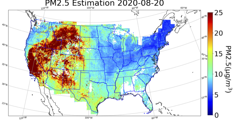
In this study, we present a nationwide machine learning model for hourly PM2.5 estimation for the continental United States (US) using high temporal resolution Geostationary Operational Environmental Satellites (GOES-16) Aerosol Optical Depth (AOD) data, meteorological variables from the European Center for Medium Range Weather Forecasting (ECMWF) and ancillary data collected between May 2017 and December 2020. A model sensitivity analysis was conducted on predictor variables to determine the optimal model. It turns out that GOES16 AOD, variables from ECMWF, and ancillary data are effective variables in PM2.5estimation and historical reconstruction, which achieves an average mean absolute error (MAE) of 3.0 μg/m3, and a root mean square error (RMSE) of 5.8 μg/m3. This study also found that the model performance as well as the site measured PM2.5concentrations demonstrate strong spatial and temporal patterns. Specifically, in the temporal scale, the model performed best between 8:00 p.m. and 11:00 p.m. (UTC TIME) and had the highest coefficient of determination (R2) in Autumn and the lowest MAE and RMSE in Spring. In the spatial scale, the analysis results based on ancillary data show that the R2 scores correlate positively with the mean measured PM2.5 concentration at monitoring sites. Mean measured PM2.5 concentrations are positively correlated with population density and negatively correlated with elevation. Water, forests, and wetlands are associated with low PM2.5 concentrations, whereas developed, cultivated crops, shrubs, and grass are associated with high PM2.5 concentrations. In addition, the reconstructed PM2.5 surfaces serve as an important data source for pollution event tracking and PM2.5 analysis. For this purpose, from May 2017 to December 2020, hourly PM2.5 estimates were made for 10 km by 10 km and the PM2.5 estimates from August through November 2020 during the period of California Santa Clara Unite (SCU) Lightning Complex fires are presented. Based on the quantitative and visualization results, this study reveals that a number of large wildfires in California had a profound impact on the value and spatial-temporal distributions of PM2.5 concentrations.
Yu, Xiaohe, David J. Lary, and Christopher S. Simmons. 2021. “PM2.5 Modeling and Historical Reconstruction over the Continental USA Utilizing GOES-16 AOD” Remote Sensing 13, no. 23: 4788. https://doi.org/10.3390/rs13234788